- Details
- Written by AUPHR AUPHR
- Published: 26 September 2012 26 September 2012
- Hits: 88535 88535
For Immediate Release September 26, 2012
Contact: This email address is being protected from spambots. You need JavaScript enabled to view it.
Portland Becomes the Latest City to See the Israel-Palestine Conflict Played Out on City Buses as Portlanders Learn about Israel’s Taking Over Palestinian Land
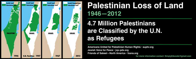
Portland, OR – Beginning on September 30th, on the exteriors of MAX trains and Tri-Met buses cruising through Portland’s busiest intersections, a series of four maps will powerfully portray an important aspect of the Israeli-Palestinian conflict – the battle for control of land.
The first map (1946), approximately a year before Israel was created, shows that Jewish communities owned no more than 6% of historic Palestine and represented 30% of the population.
The second map spells out the United Nations partition plan of 1947, which awarded the Jewish community a state on 55% of the land alongside a much reduced Palestine even though Palestinians were the strong majority of the land’s inhabitants.
The third map (1948-1967) displays the armistice lines from the 1948 Arab-Israeli war. In this map Israel controls 78% of the land.
The fourth map is where we are today. In the 1967 war, Israel took control of the West Bank and the Gaza Strip. The Israeli occupation – now in its 45th year - of the West Bank is being made permanent as Israel systematically takes more and more Palestinian land to accommodate Israel’s massive settlement project to establish irreversible “facts on the ground”. Over half a million Israeli settlers now live in the occupied West Bank. Under international law, it is illegal for Israel to move Israeli settlers into the occupied Palestinian territories. Israel is on the verge of annexing 60% of the West Bank.
These maps attract attention because they graphically tell a story of dispossession.
They point to an important reality: that as Israel has expanded in what was historic Palestine, the majority of the indigenous people of that land - the Palestinians - have either been driven off their land, or, where they remain, have no sovereignty and few rights.
These maps are part of a campaign to educate Americans about what’s really going on in Israel-Palestine and are sponsored by a number of individuals and three organizations: Friends of Sabeel - North America, Americans United for Palestinian Human Rights and Jewish Voice for Peace - Portland. These groups believe that massive American support for Israeli policies of expansion is detrimental to the cause of peace and to America’s standing in the world. “Israel’s expansionist policies and occupation of Palestinian land,” said Maxine Fookson of Jewish Voice for Peace, “is supported by virtually no country in the world except the U.S. It is our hope that these ads will promote informed dialogue and challenge American policy makers to replace their blind support for Israel with a commitment to justice and equality for all peoples of the region.”
The maps will run on 20 trains and 9 buses for at least a month.